United Kingdom Zip Code
United Kingdom Zip code / United Kingdom Postcode
UK zip code also known as British zipcodes are used in the United Kingdom, British Overseas Territories, and Crown dependencies. They are alpha-numeric and were established nationally between 11 October 1959 and 1974, with help from the General Post Office (Royal Mail). A "full postcode" consists of two or more addresses, generally one main delivery point, and is known as a "postcode unit."
Structure of UK Postal Code
A postcode is combination of two alphanumeric strings that display.
First, the Post Town and, second, a tiny group of addresses in that post town.
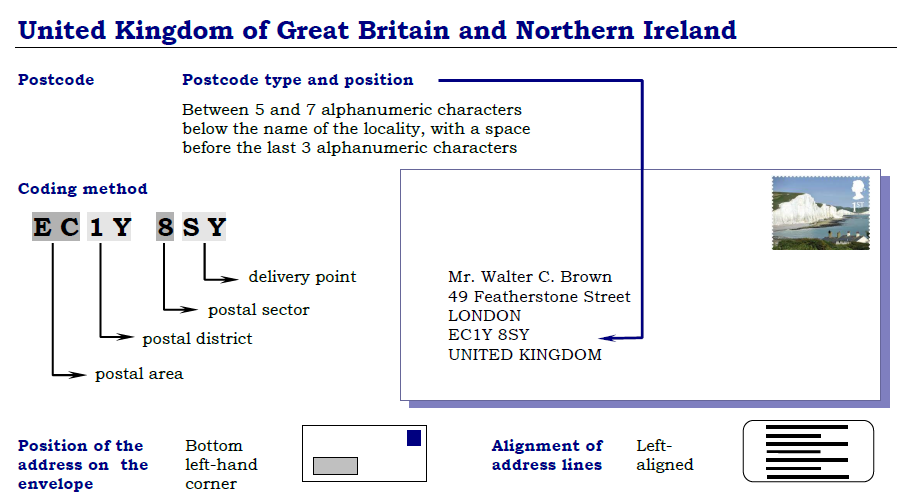
The first (Outward code or Outcode) is generally two to four characters long, while the second (Inward Code or Incode) always has three. The UK postcodes area and district are indicated by the Outcode, which comprises one to two letters followed by one digit or two digits, or one digit and one letter.
This is accompanied by a gap, after which comes the Incode, which specifies the postcode sector and delivery location (usually a group of about 15 residences). The incode always contains three characters. The first two are numbers (representing a district's sectors) and the last two letters (denoting delivery locations, which are assigned to streets, sides of a road, or individual properties).
Use of Letters
A UK postcode district is usually, but not consistently named after a major city or town - such as B for Birmingham. A few are geographic in nature, such as HS for the Outer Hebrides and FY for Fylde (the region around Blackpool).
Several post towns are not designated by a letter in each postcode area; nevertheless, they will generally be one or more UK postal code districts. For example, the GU postcode region, named after Guildford, covers southern England. Guildford is made up of postal districts GU1 and GU2.
The town of Guildford, about 10 kilometers (6 miles) to the north, is in the postal district GU22. The postcode area's name refers to its central part, such as B1 (Birmingham), LS1 (Leeds), M1 (Manchester). However, other post towns in the region are generally treated alphabetically, particularly in London, e.g Chingford on the north-eastern side of London being E4. In contrast, adjacent Walthamstow to the south is E17—or geographically—the Outer Hebrides area HS numbering the districts north to south.
Numbering Rules
Generally, large post towns are numerically ordered from the core outwards, with outer settlements having higher-numbered districts. However, within a postal region, the numerous post towns may be numbered in various ways. The area's name was derived from the town in which it is located, except this. Within a UK postcode area, the centrality of a postcode district cannot always be accurately inferred from the postcode. SE1, for example, covers a vast region of Central London south of the Thames, whereas SE2 covers Abbey Wood at the other side of the line. The area is shown in postcode format.
UK Postcode Example:
SW1W 0NY,
GU16 7HF,
L1 8JQ
Significance
In addition to assisting with mail sorting, postcodes have been used for various purposes, including commercial vehicle registration and calculating insurance premiums, route planning software destination designations, and the lowest level of aggregation in census enumeration. The Postcode Address File database is a massive collection of data that includes the boundaries of each postcode unit and complete address information for about 29 million addresses (delivery points) currently held, maintained, and updated regularly.
Development
The original system of named postal districts, which was established in London and other large cities in 1857, ultimately evolved into its present form. In 1917, London was divided into broad numbered subdivisions, and the rest of the country followed this in 1934.
UK Postal Codes List The first letter or the first two letters represent the name of the region. This combination is usually formed from an abbreviation of the main city of the region, such as NG for Nottingham City. Other commonly used abbreviations are: BN (Brighton) BT (Northern Ireland) CB (Cambridge) CF (Cardiff) E (east of London) EC (east and central London) EH (Edinburgh) G (Glasgow) IV (Inverness) L (Liverpool) M (Manchester) N (North London) NE (Newcastle) NG (Nottingham) NN (Northampton) NP (Newport) NO (a North Witch) NW (North West London) OX (Oxford) SE (South East London) SW (South West London) W (West London) WC (West Central London) WR (Worcester) YO (York) and ZE (Shetland) Thus these postcodes act as a very important tool in identifying these locations. Thus use our UK postcode finder to know the postcode of any location in the country.
FAQ
1. What is Birmingham postcode area?
Birmingham post code is B and area code is 0121.
2. What is British postcode?
British Postcode, British postal codes is same as the uk zipcode.
3. UK zipcode and UK Area code are same?
No, both are different, Zipcode is used for delivery a parcel for geographical area. and area code is also known as the STD code (Subscriber Trunk Dialing) when dialing a number.
4. What is england postal code?
you can postal of England postal code.
5. What is my zip code uk
you can check your zip code in uk Current Location Zipcode.
6. What is postcode district?
Postcode district is the first part of a UK postcode and consist of one or two letters that indicate the general area of the location. For example, BT (Northern Ireland), CB (Cambridge), EC (east and central London)
7. What is postcode sector?
Postcode sectors are the second part of a UK postcode and consist of a number and a letter. They further subdivide the postcode district into smaller areas, with each sector representing approximately 3k addresses. For example, "SW1W 0NY" is a postcode sector in the SouthWest area of London.
8. What is outward code and inward code?
Each postcode is divided into two separate part by a single space: the outward code and the inward code respectively.
The outward code includes the postcode area and the postcode district, respectively.
The inward code includes the postcode sector and the postcode unit respectively.
Mr A. Payne
Aramark Ltd.
30 Commercial Road
Fratton
Portsmouth
Hampshire
Po1 1Aa
United Kingdom
- Toal Postal Code in Country:- Total 3074 Postal Code In United Kingdom
- Postal Code Type :- 7-digit(alphanumeric)
- Toal Population :- 67.7Million (May2023)
- Capital Name :-London
- Dialing Code :-44